We've updated our Privacy and Cookies Policy
We've made some important changes to our Privacy and Cookies Policy and we want you to know what this means for you and your data.
Tonga Volcano: Survey maps area since January eruption
Image source, Maxar
It was so violent and powerful it sent a cloud of ash and water vapour high into the atmosphere and caused a devastating tsunami that swept across the ocean.
Since then, experts have been using mapping equipment to study the effects of the eruption on the seabed.
And they have found it's been completely reshaped.
'The highest recorded eruption column in human history'
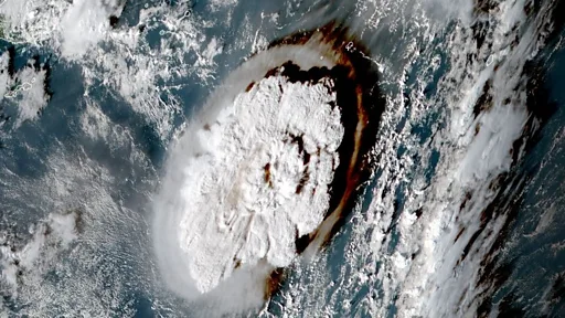
Experts have estimated that as much as 10 cubic kilometres of rock, ash and debris blasted out in the eruption - that's enough power to shift nearly 4,000 Egyptian pyramids in one go!
Ejected high into the sky "some of that material went beyond even the stratosphere into the mesosphere - the highest recorded eruption column in human history," Dr Kevin Mackay told В鶹№ЩНшКЧТіИлїЪ News.
Dr Mackay has been leading the project, focusing on the Hunga-Tonga Hunga-HaК»apai seamount using vessels from New Zealand and the UK.
When the volcano blew, the scorching rock that was hurled to the ocean surface and up into the atmosphere fell and scattered across a wide area.
Their mapping equipment has now discovered that this hot ash and rock debris has reshaped the seafloor over a distance of 80km (50 miles) from where the eruption took place.
How was the area mapped?
The National Institute of Water and Atmospheric Research (Niwa) survey was carried out in two parts.
The first stage mapped the seafloor around the volcano using specialised equipment on board New Zealand's Research Vessel Tangaroa.
Image source, AFP
The equipment is highly sophisticated and can create maps and models of the movement of the rock and debris that scattered, generating a clear picture of how the landscape of the seabed has been altered by this huge underwater event.
Image source, SEA-KIT/NIWA/Nippon Foundation/SEABED2030
The second stage was to launch a British robot boat USV Maxlimer directly above the volcano's opening - called a 'caldera' - beneath the waves.
The role of this remote-controlled robot is to monitor any ongoing volcanic activity from the surface. You would think it would be operated by someone on board the Tangaroa - but you'd be wrong! It's actually being controlled remotely from the UK, 16,000 miles away!
Equipped with thermal cameras, echosounder radar, 4G and satellites, it's looking for traces of ash in the ocean and monitoring where its coming from. So far the results suggest a new vent 200 metres below the surface is releasing it.
Image source, NIWA
This science is really important because the data will help island nations in the Pacific to understand the number of volcanoes in the region and the risk they pose. As some become extinct, other new, more powerful ones may be created in their place - so it's vital scientists understand where they are and how they behave when they erupt.
The information can also help predict the nature of future eruptions.
As this eruption proved in January, submarine volcanoes can have dangerous consequences so people who live close to them need advanced warning systems and infrastructure that can help protect them from tsunamis.
These waves have the most far-reaching and devastating impacts. The biggest wave to hit Tonga's main island, Tongatapu occurred just over 45 minutes after the first major eruption.